Pedra da Mina - Brasil
| Pedra da Mina | |
|---|---|
| |
| Elevation | 2,798.39 m (9,181 ft) |
| Prominence | 2,068 m (6,785 ft) |
| Location | |
| Location | Between the cities of Queluz, São Paulo and Passa Quatro, Minas Gerais |
| Range | Serra da Mantiqueira |
| Coordinates | 22°25′S 44°51′W |
| Climbing | |
| Easiest route | From "Passa Quatro" |
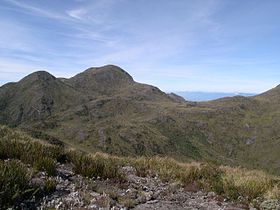
Pedra da Mina is a high mountain in the Brazilian state of São Paulo and one of the highest in the Serra da Mantiqueira mountain range. It is located at the border with Minas Gerais, leaving the status of highest mountain fully located within São Paulo to its fellow Serra da Mantiqueira mountain Pico dos Marins.
Near the mountain, there is the Rio Claro spring, located at 2,500 metres above sea level, the highest river spring in Brazil.
First ascension
The summit of Pedra da Mina was first reached by a group of eight people, in July 1955. Until 1990, the place kept a quite untouched spot, due to the difficulty of reaching the summit of the mountain. During this first expedition, the height measured by a barometer was of 2,718 metres. Until the new measuring in 2000, Pico das Agulhas Negras was still considered the highest point of Serra da Mantiqueira.