Bananal, São Paulo - Brasil
| Município da Estância Turística de Bananal
Bananal | |||
|---|---|---|---|
| |||
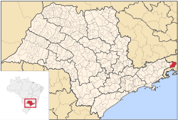 Location in the state of São Paulo and Brazil Location in the state of São Paulo and Brazil
| |||
| Coordinates: 22°41′02″S 44°19′25″W | |||
| Country | Brazil | ||
| Region | Southeast | ||
| State | São Paulo | ||
| Settled | July 10, 1783 | ||
| Government | |||
| • Mayor | Mirian Ferreira de Oliveira Bruno (PP) | ||
| Area | |||
| • Total | 616.320 km (237.962 sq mi) | ||
| Elevation | 454 m (1,490 ft) | ||
| Population (2008) | |||
| • Total | 10,727 | ||
| • Density | 16.5/km (43/sq mi) | ||
| Time zone | UTC-3 (UTC-3) | ||
| • Summer (DST) | UTC-2 (UTC-2) | ||
| HDI (2000) | 0.758 - medium | ||
| Website | www.bananal.sp.gov.br | ||

Bananal is the easternmost city in the state of São Paulo in Brazil. The population density is 16.5/km². The population in 2008 was 10,727. The area is 616.320 km².
Its boundaries are three cities of Rio de Janeiro state ( Barra Mansa to the north, Rio Claro to the east and Angra dos Reis to the south), as well as São José do Barreiro and Arapeí (both in São Paulo) to the west. It is the easternmost municipality in Sâo Paulo state.